No products in the cart.
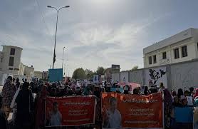
Zāhedān – Balūchestān province | Quetta of Balochistan province
Aarcu lacus, quis aliquet odio bibendum non. Nam vitae libero mauris. Suspendisse vitae purus ligula. Morbi sed diam eget dolor posuere convallis vel vel nisl. Nulla sagittis efficitur ex, at sodales massa pulvinar a. Nunc quis lacinia eros. Fusce ac ipsum gravida, tristique sed felis augue dictum nec consectetuer quis. Elementum eu arcu nunc ornare.
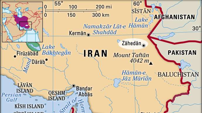
Zāhedān, city and capital of Sīstān va Balūchestān province, southeastern Iran, near the borders of Afghanistan and Pakistan. It is situated about 225 miles (360 km) southeast of Kermān in an arid zone, at an elevation of 4,435 feet (1,352 metres). The population comprises Shīʿite Muslim Persians and Sunnite Muslim Baluchs. Zāhedān is one of the less economically developed cities in Iran; local industry produces bricks, milled rice, livestock feed, processed foods, mats and baskets, embroidered articles, and ceramics.
Strategically located along routes linking Central Asia and Makran sea ports , Persian Gulf to the south, the city has benefited from regional trade. It has also become an entrepôt for narcotics trafficking and other criminal enterprises across international borders. Roads link it with the Balochistan cities of Zābol, Īrānshahr, Sarbaz, Chāh Bahār, and Sarārān and with points in Afghanistan and Pakistan. It is the terminus of a rail line connecting two Western Balochistan with Quetta, Capital of eastern Balochistan. Construction began in the mid-1990s on a new line to Kermān to link Europe and the Indian subcontinent. The city also has an international airport. Notable historic buildings include a ruined citadel, in the centre of the city, and the Friday Mosque (Masjid-e Joṃeh). Pop. (2006) 567,449.
Quetta, also spelled Kuttah, city, district, and division of Balochistan province, in Pakistan. The name is a variation of Shāl, a Baluchi word and the city is still locally known by its ancient name of Shāl or Shālkot.
The city is the divisional and district headquarters and is an important marketing and 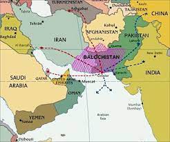 communications centre at the north end of the Shāl Valley about 5,500 feet (1,675 metres) above sea level. It is the southernmost point in a line of frontier posts and in the system of strategic roads and railways near the northwest (Afghanistan) border. Commanding the Bolān and Khojak passes, Quetta was occupied by the British in 1876; a residency was founded by Sir Robert Sandeman, and the town developed around its strongly garrisoned army station. Incorporated as a municipality in 1896, its Army Command and Staff College was opened in 1907. A violent earthquake partially destroyed the city in May 1935, with a loss of 20,000 lives. Now a market centre for western Afghanistan, North Western Balochistan in Iran, and part of Central Asia, its industries include cotton mills, a sulfur refinery, coke briquetting plants, a thermal power station, and fruit canneries. The city is the site of a geophysical institute, the Geological Survey of Pakistan, Sandeman Library, and two government colleges affiliated with the University of Peshawar. The University of Balochistan was established at Quetta in 1970. The city is also an important summer resort.
Quetta district is bounded to the north by Pishīn district, to the west by Afghanistan, to the east by Ziārat and Harnāi districts, and to the south by Mastung and Nūshki districts. Quetta district, whose area has been reduced by the government as the population has grown, is geographically small compared with other districts in the province. Physically, it is mostly composed of valleys 1,400–1,700 metres (4,500–5,500 feet) above sea level, but its western edge lies along the foothills of the Central Baluch and Brāhui range.
Please login to join discussion
easyComment URL is not set. Please set it in Theme Options > Post Page > Post: Comments
Related Posts
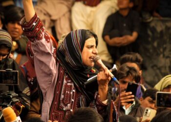
Fariba Borhanzehi warns of increased executions to create terror in Iran
Fariba Borhanzehi warns of increased executions to create terror in Iran According to Baloch Media, on Thursday, Fariba Borhanzehi, a member of the Balochistan People's Party and human rights activist, stated in an interview with Voice of…