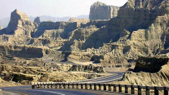
Makrān, in occupied Baluchistan also spelled Mekrān, division of Balochistān province, Pakistan. Administratively it comprises Turbat, Gwādar, and Panjgūr districts and has an area of 23,460 sq mi (60,761 sq km). It is bounded by the Siāhān range (north), which separates it from Khārān district, by Kalāt and Las Bela districts (east), the Arabian Sea (south), and Iran (west). Makrān has a seacoast about 200 mi (320 km) long. The interior of the division is mountainous, with the southernmost portion of the Makrān Range lying on the coast; another of its ranges occupies the central area, while in the north the highest portion of the Makrān range is separated from Khārān district by the Siāhān range. These ranges consist of a sequence of ridges, scoured and cut by torrential watercourses that are dry except after heavy floods. The Dasht River in the west is the major river. Temperatures vary, with the dry central area having the greatest extremes; the north has cool summers and cold winters.
With the arrival of the British in 1872 a commission was sent to demarcate the Persia–Makrān boundary. In 1903 Lord Curzon landed at Pasni and appointed assistants at Panjgūr and Gwādar. With the British maintaining political control, Makrān continued as an administrative division of Kalāt until Pakistan’s creation in 1947. Makrān became a part of the Baluchistan States Union in 1949.
Barley, wheat, rice, and dates are the chief agricultural products and the main sources of income. Fishing (sardines and sharks) and leatherwork are also important. Turbat, a district headquarters, has an airstrip and is located on a fair-weather road 250 mi from Kalāt. Pasni, which is about 25 mi from Turbat, was destroyed by an earthquake in 1945 and has since been rebuilt. Panjgūr is a district headquarters, to which most of the division offices of Makrān move during the summer. Jīwani is a seaport 300 mi from Karāchi; its population comprises the majority of the Baluchi Med who live in their traditional mud huts. Gwādar is an important fishing and trading centre with many commercial functions.
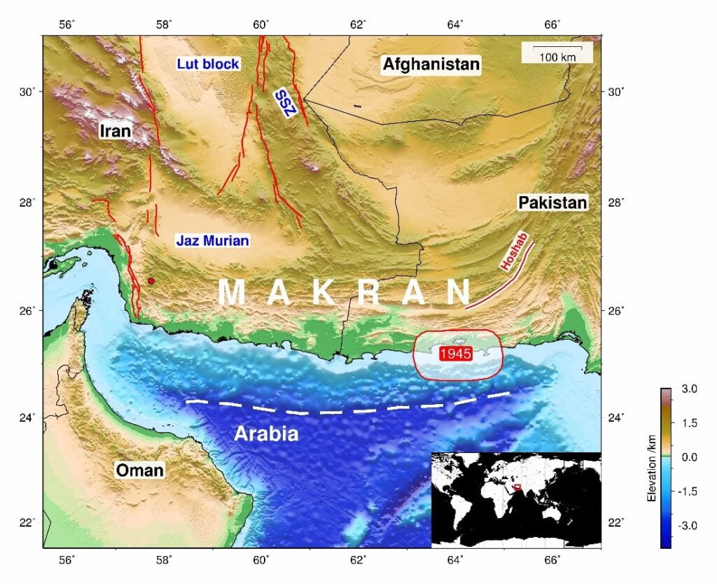
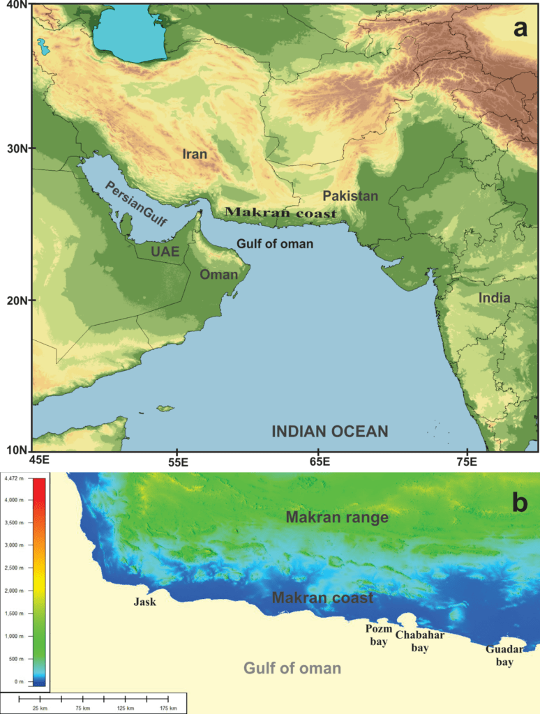
Makran, also spelled Mekran, in Balochistan Iran, occupied Baluchistan Mokrān, Pakistani Makrān, coastal region of Baluchistan in southeastern Iran and southwestern Pakistan, constituting the Makran Coast, a 600-mi (1,000-km) stretch along the Gulf of Oman from Raʾs (cape) al-Kūh, Iran (west of Jask), to Lasbela District, Pakistan (near Karāchi). The name is applied to a former province of Iran, and the Makran of Pakistan is sometimes known as Kech Makran to distinguish it from the Iranian portion.
Occupied Baluchistan Makran, a former princely state that acceded in 1948, was constituted after 1955 a district (area 28,164 sq mi [72,944 sq km]) of Kalāt division. Now a part of Baluchistan Province, Pakistan, it is bounded east by Khuzdār and Lasbela districts, south by the Arabian Sea, west by Iran, and north by the Siāhān Range. Turbat is district headquarters and Panjgūr the chief town of the interior. Aside from the coastal areas, the terrain is mostly mountainous, consisting of east–west parallel ranges rising to about 7,000 ft (2,100 m) and enclosing fertile narrow valleys, including those of the Kech (upper Dasht) and Bolida. The chief spring crops ( jopag ) are wheat and barley, and the autumn crop (eraht) is jowār (sorghum). Dates, however, are the main crop; cultivation has been extended by irrigation projects. Laghati (compressed dates) constitute the staple food of the poor. Irrigation is provided by flooding, subterranean channels (kārez), riverbed pools (kaurjo), and springs. Sheep are also bred. Makran’s 200-mi sandy coastline in Pakistan lies longitudinally with many hammerhead peninsulas. Past volcanic action is evidenced by occasional volcanoes of boiling mud along the coast. The chief ports are Gwādar, which belonged to the Sultanate of Muscat and Oman till 1958; Ormāra; and Pasni, all being difficult of approach because of off-shore sandbars. Fishing is the main coastal occupation.
Makran, the ancient Gedrosia of the Persian and Macedonian empires and the scene of Alexander the Great’s retreat from India (325 BC), has been strategically significant in the history of Iran and India. The etymology of the name is uncertain, chiefly regarded either as a corruption of Māhī Khūrān (Fish Eaters), identified with the Ichthyophagoi (now represented by the Mēds) mentioned in the Indica of the 2nd-century-AD Greek historian Arrian, or as a Dravidian name appearing as Makara in the Bṛhat-saṃhitā of the 6th-century-AD astrologist Varāhamihira in a list of tribes contiguous to India on the west.
The population is predominantly Arab, the Arabs having held Makran before they conquered Sind in the 5th century. Other groups are the Darzadis, regarded as of aboriginal descent; Mēds (fishermen); and Koras (seamen). The coastal blacks are descended from imported slaves.